 van wyk journeys
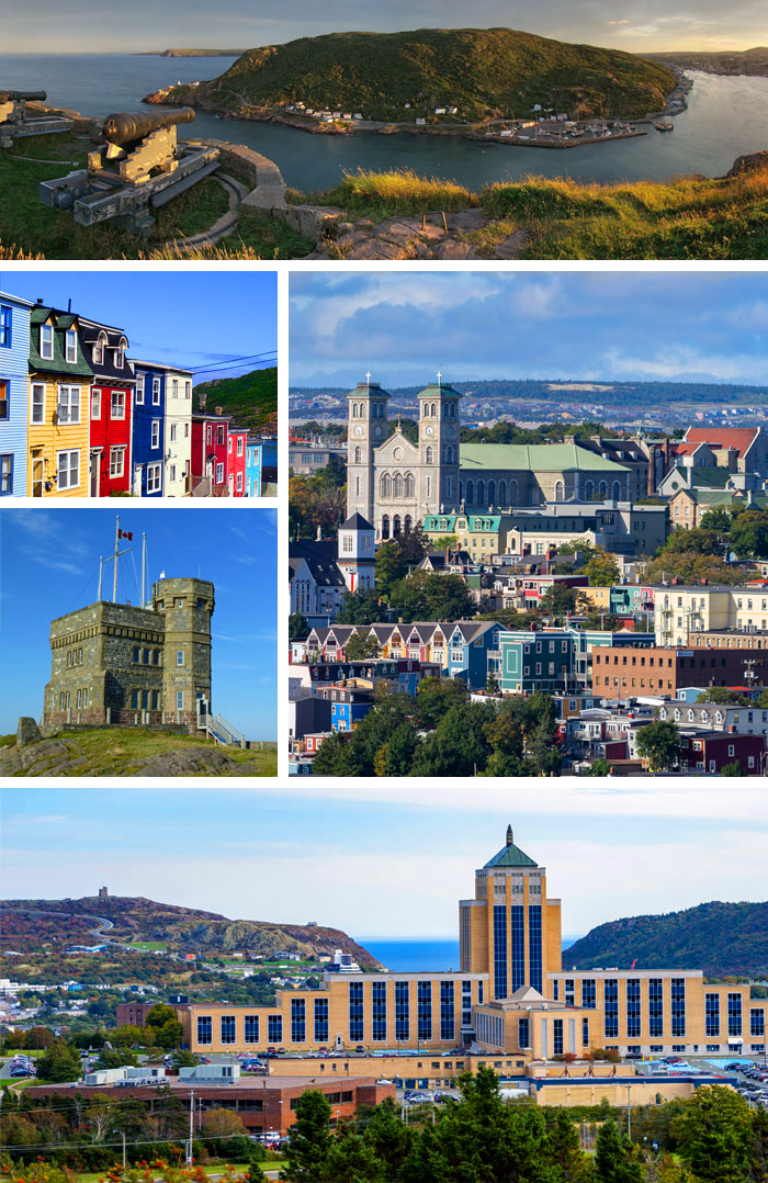
St. John’s is the capital and largest city of the Canadian province of Newfoundland and Labrador. It is located on the eastern tip of the Avalon Peninsula on the island of Newfoundland. The city spans 446.04 km2 (172.22 sq mi) and is the easternmost city in North America (excluding Greenland).[8][9][10][11]
Its name has been attributed to the belief that John Cabot sailed into the harbour on the Nativity of John the Baptist in 1497, although it is most likely a legend that came with British settlement. A more realistic possibility is that a fishing village with the same name existed without a permanent settlement for most of the 16th century.[12] Indicated as São João on a Portuguese map from 1519, it is one of the oldest cities in North America.[13] It was officially incorporated as a city in 1888. With a metropolitan population of approximately 212,579 (as of 9 February 2022), the St. John’s Metropolitan Area is Canada’s 20th-largest metropolitan area and the second-largest Census Metropolitan Area (CMA) in Atlantic Canada, after Halifax.[14]
The city has a rich history, having played a role in the Seven Years’ War, the American Revolutionary War, and the War of 1812. Italian inventor Guglielmo Marconi received the first transatlantic wireless signal in St. John’s.[15] Its history and culture have made it into an important tourist destination.[16] St. John’s was referred to as Baile Sheáin (Johnstown), in the poetry of Donnchadh Ruadh Mac Conmara (1715–1810), and among speakers of the Irish language in Newfoundland.[17]
Credit Wikipedia® St. John’s, Newfoundland and Labrador – Wikipedia
Photo credit By Judicieux – Made with https://commons.wikimedia.org/w/index.php?curid=63779406
Quidi Vidi is a neighbourhood in St. John’s, Newfoundland and Labrador. Its pronunciations vary, even amongst longtime residents, but “Kiddy Vidi” is the most common. One theory behind the name is that it was named after a beloved cat named Vidi. The village is adjacent to Quidi Vidi Lake (where the Royal St. John’s Regatta is held the first Wednesday in August, weather permitting). Quidi Vidi’s harbour is known as “The Gut”. Located in Quidi Vidi is the Quidi Vidi Battery Provincial Historic Site. The village is home to several small businesses.
Credit Wikipedia® Quidi Vidi – Wikipedia
William van Wyk2016 015874352578") Quidi Vidi Village
Quidi Vidi Village
William van Wyk2016 015874352578")
William van Wyk2016 015874352578")
William van Wyk2016 015874352578")
William van Wyk2016 015874352578")
William van Wyk2016 015874352578")
Petty Harbour–Maddox Cove is a town of approximately 950 people located on the eastern shore of the Avalon Peninsula in the province of Newfoundland and Labrador, Canada. It is nestled deep in the heart of Motion Bay about 10 kilometres (6.2 mi) south of St. John’s. The present town is approximately 200 years old, though the site has been continuously occupied since at least 1598. During King William’s War, the village was raided by French forces in the Avalon Peninsula Campaign.
Petty Harbour–Maddox Cove is the site of the Petty Harbour Generating Station, the first hydroelectric generating station in Newfoundland and Labrador.[2]
Credit Wikipedia® Petty Harbour–Maddox Cove – Wikipedia
William van Wyk2016 015874352578") Petty Harbour
Petty Harbour
William van Wyk2016 015874352578")
William van Wyk2016 015874352578")
William van Wyk2016 015874352578")
William van Wyk2016 015874352578")
William van Wyk2016 015874352578")
William van Wyk2016 015874352578")
Cape Spear (French: Cap d’Espoir) is a headland located on the Avalon Peninsula of Newfoundland near St. John’s in the Canadian province of Newfoundland and Labrador. At a longitude of 52°37′ W, it is the easternmost point in Canada and North America, excluding Greenland.[1]
Cape Spear is within the municipal boundaries of the city of St. John’s, located about 12 kilometres (7.5 mi) from downtown St. John’s.[3]
The Portuguese named this location Cabo da Esperança, meaning “cape of hope”, which became Cap d’Espoir in French and finally “Cape Spear”.
Cape Spear is the trailhead/trail end for two components of the East Coast Trail.[4]
Credit Wikipedia®
William van Wyk2016 015874352578")
William van Wyk2016 015874352578")
William van Wyk2016 015874352578")
William van Wyk2016 015874352578")
William van Wyk2016 015874352578")
William van Wyk2016 015874352578")
William van Wyk2016 015874352578")
William van Wyk2016 015874352578")
William van Wyk2016 015874352578")
William van Wyk2016 015874352578")
William van Wyk2016 015874352578")
William van Wyk2016 015874352578")
William van Wyk2016 015874352578")
William van Wyk2016 015874352578")
Signal Hill Cabot Tower
Signal Hill is a hill which overlooks the harbour and city of St. John’s, Newfoundland and Labrador, Canada. The majority of Signal Hill, including Cabot Tower, is designated a National Historic Site. The highest point, Ladies’ Lookout, is 167 m (548 ft) high.
Due to its strategic placement overlooking the Narrows, the only entrance to the harbour, fortifications date back to the mid 17th century. On 12 December 1901, the first transatlantic wireless transmission was received there by Guglielmo Marconi.
Adjacent to the National Historic site is the Johnson Geo Centre and Johnson Geo Vista Park. The community of The Battery lies on the slope of the hill overlooking the harbour, and Memorial University of Newfoundland has a campus on the lower slopes, in the former Battery Hotel.
Credit Wikipedia®


The Rooms
The Rooms is a cultural facility in St. John’s, Newfoundland and Labrador, Canada. The facility opened on June 29, 2005 and houses the Art Gallery of Newfoundland and Labrador, the Provincial Archives of Newfoundland and Labrador and the Provincial Museum of Newfoundland and Labrador.[2]
The facility was constructed on a hill overlooking the port city, at a historic location once occupied by Fort Townshend.
Credit Wikipedia®


Jelly Bean Row
Built on hilly terrain and steep maze of residential streets, in St. John’s is typically painted in bright colours, hence the nickname Jelly Bean Row for downtown row housing. However, downtown St. John’s wasn’t always as bright and colourful as it is today. The coal soot that blanketed St. John’s in much of the 19th and 20th centuries made light exterior paint colours impractical. Houses along downtown streets and lanes were mostly dark shades of green, red, brown, and grey. Bright colours were introduced in the 1970s when coal was no longer used.


Best Regards,
Bill & Joan
from vanwykjourneys.ca
St John’s and Surroundings
St. John’s is the capital and largest city of the Canadian province of New…
The hike from Signal Hill to the Jag Hotel
Joan and I decided to hike from Signal Hill back to our hotel, the JAG Hotel—a 4.2 km trek that took…